


|
New York New Jersey Pennsylvania West Virginia Ohio Indiana Illinois Iowa Nebraska Wyoming Utah Nevada California |
|
|
Wyoming |
| Maps | |
 |
 1924 strip map (137 K) |
| Place Names | ||
|
The place names for each state are listed from east to west as
you read down the columns, then across from left to
right. 1915-1916 |
||
|
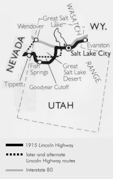
Wyuta Station Wasatch Castle Rock Emory Station Main Forks Coalville Hoytsville Wanship Kimball's Ranch |
Roach's Ranch Salt Lake City Pleasant Green Ragtown Garfield Lakepoint Milltown Grantsville Timpie Point |
Iosepa Brown's Ranch Indian Ranch Severe Farm Orr's Ranch County Well Fish Springs Callao Ibapah |
| Organizations and Museums | Utah chapter of the Lincoln Highway Association |
| Books |
|
The Lincoln Highway in Utah By Jesse G. Peterson Published by the Utah Chapter of the Lincoln Highway Association |
Last modified on March 5, 2000