

|
New York New Jersey Pennsylvania West Virginia Ohio Indiana Illinois Iowa Nebraska Wyoming Utah Nevada California |
|
|
Utah |
| Maps | |
 |
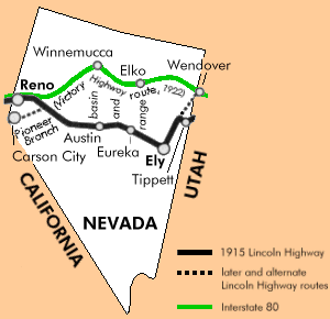
1924 strip maps
 Western Nevada (148 K)  Eastern Nevada (128 K) |
| Place Names | ||
|
The place names for each state are listed from east to west as
you read down the columns, then across from left to
right. 1915-1916 |
||
|
Tippett Anderson's Ranch Schellbourne Magnuson's Ranch McGill East Ely Ely Lane Copper Flat Reipetown Kimberly Jake's Summit Mooreman's Ranch |
Rosevear's Ranch White Pine Summit Six Mile House Pancake Summit Fourteen Mile House Pinto House Eureka Austin New Pass Canyon Alpine Ranch Eastgate Westgate Frenchman's Station |
Sand Springs Salt Wells Grimes Ranch Fallon Hazen Fernley Wadsworth Derby Vista Sparks Reno Verdi |
Last modified on October 7, 1998