

|
New York New Jersey Pennsylvania West Virginia Ohio Indiana Illinois Iowa Nebraska Wyoming Utah Nevada California |
|
|
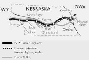
Iowa |
| Maps | |
 |
1924 strip maps
 Western Nebraska (100 K)  Eastern Nebraska (124 K) |
| Place Names | |||
|
The place names for each state are listed from east to west as
you read down the columns, then across from left to
right. 1915-1916 |
|||
|
Omaha Elkhorn Waterloo Valley Fremont Ames North Bend Rogers Schuyler Richland P.O. Columbus Duncan |
Silver Creek Clarks Central City Chapman Grand Island Alda Wood River Shelton Gibbon Kearney Odessa Elm Creek |
Overton Lexington Cozad Gothenburg Brady Maxwell North Platte Hershey Sutherland Paxton Roscoe Ogallala |
Brule Megeath Big Springs Chappell Lodge Pole Sunol Sindey Potter Dix Station Kimball Bushnell |
| Web Sites |
| Lincoln Highway photo archive by the Nebraska Department of Roads |
| Books |
|
Lincoln Highway: Nebraska by Gregory M. Franzwa Published by Patrice Press, 1996. |
Last modified on October 7, 1998