
| A Brief History | |
| · | Origins |
| · | Picking a Route |
| · | From Dirt To Concrete |
| · | The End of Named Highways |
| Historic Newspaper Articles | |
| · | Highway Boosters Will Gather Tonight San Francisco Chronicle; October 31, 1913 |
| · | Public To See Dedication of Great Highway San Francisco Examiner; October 31, 1913 |
| · | Plans for Local Demonstration Under Way San Francisco Chronicle; October 26, 1913 |
|
|
From Dirt to Concrete |
On July 1, 1913, the association decided to call the coast-to-coast highway the Lincoln Highway, and it was officially incorporated as the Lincoln Highway Association. Henry Joy was elected as president. Carl Fisher, who was elected vice-president, was not present. He had departed with the Indiana Automobile Manufacturers association on a trip to the West Coast. The "Hoosier Tour" was intended, in part, to explore possible routes for the Lincoln Highway. The tour route included Colorado and Kansas. While Fisher tried to distinguish the Hoosier Tour route from the eventual route of the Lincoln Highway, he all but promised the governors of Colorado and Kansas that the highway would pass through their states. They were set up for a big disappointment.
Fisher kept the route of the Lincoln Highway a secret as long as he could because 1) he wanted the nation as a whole to support the highway, not just the states through which it would pass, and 2) he didn't know what the route was. No decision had been made. After Hoosier Tour, the association decided they needed to pick a route.
As far as Joy was concerned, directness was the most important factor. By bypassing many scenic attractions and larger cities along the way, narrow winding roadways and congestion could be avoided.

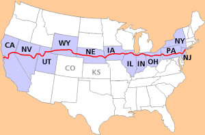
After weeks of deliberation, Henry Joy presented the route before the annual Conference of Governors in Colorado Springs. The highway started in Times Square in New York City. It passed through New Jersey, Pennsylvania, Ohio, Indiana, Illinois, Iowa, Nebraska, Wyoming, Utah, Nevada, and California, ending in Lincoln Park in San Francisco. The route did not deviate from a straight path in order to go through larger cities or national parks. It did not touch Kansas or Colorado. Joy's influence was clear.
The governors of Colorado and Kansas were embarassed for having heartily supported the Hoosier Tour, only to find themselves bypassed. After forceful appeals from Colorado's governor, the association agreed to a dogleg from Big Springs, Nebraska southwest to Denver, and then back to the main highway at Cheyenne. After the route was announced to the public one month later, the decision to include the dogleg would come back to haunt them.
Almost immediately, the Lincoln Highway Association received letters trying to change the route; it politely declined every request. The association learned its lesson. Two years later, it dropped the Denver dogleg from its maps and guides and warned drivers not to be mislead by signs in Big Springs pointing them to Denver.
|
|
From Dirt to Concrete |
Last modified on October 7, 1998